Construction Worker Tracking with Smart Hard Hats: A Buyer’s Guide

Choosing a construction worker tracking system means understanding what supervisors can see, how current that information is, and where coverage ends. This guide explains how to evaluate smart hard hats for worker location tracking, geofencing, and everyday site coordination.

Hitesh Gambhava
Nov 20, 2026Updated Nov 20, 2026
Share:
Share article on LinkedInShare article on X
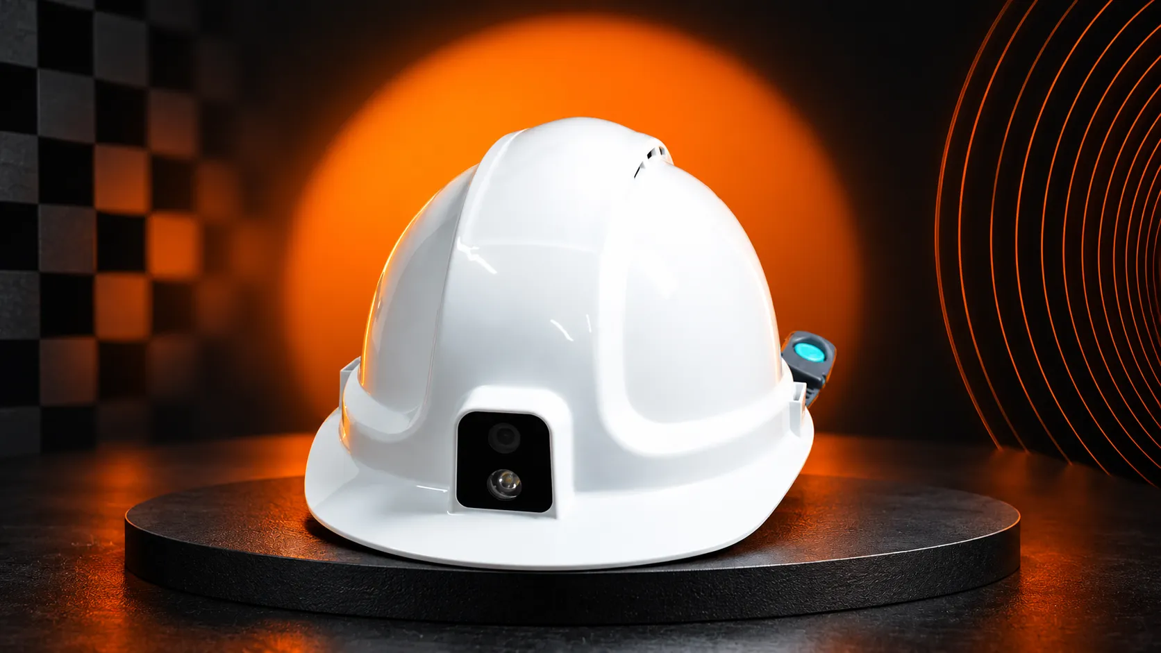
Smooth White Hard Hat at Construction Site

A gate record can tell you that a worker entered the site. It cannot tell you where that worker is now.

That distinction matters when crews move between work zones, supervisors coordinate subcontractors, or someone requests assistance. Before comparing devices, establish whether you need site attendance, zone-level visibility, or individual worker locations. Then check whether the proposed system can provide that information across your actual working areas.

For construction teams evaluating smart hard hats, the buying decision comes down to three questions: What location information do we need? Where must it work? What will supervisors do with it?
How does construction worker tracking with smart hard hats work?

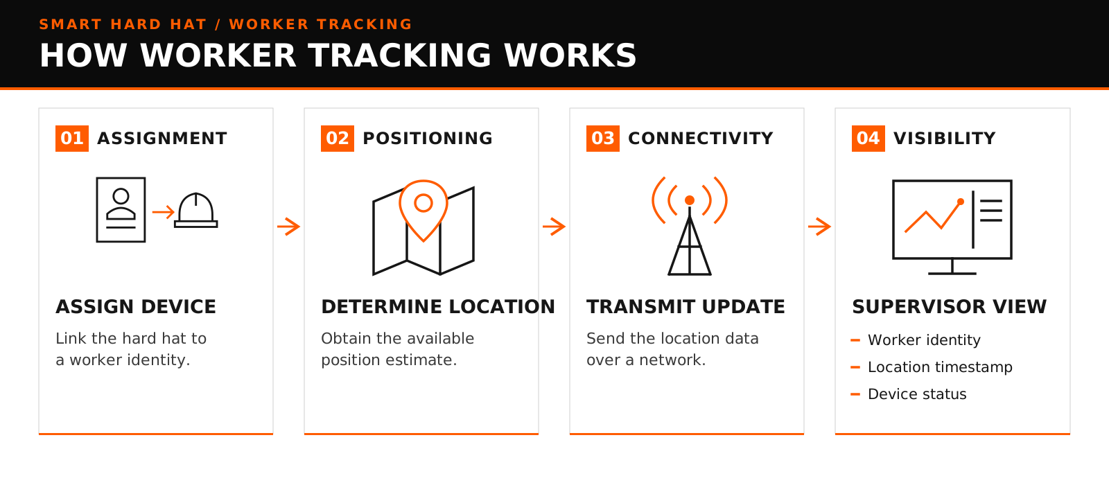
A smart hard hat tracking system connects a wearable device to software that displays location information against an assigned worker or device identity.

The process typically involves four steps:

1.

Assign the device. Link the hard hat to the correct worker for the shift.

2.

Determine its location. Use the positioning technology supported by the device and site infrastructure.

3.

Transmit the update. Send location information through the configured network.

4.

Display it for supervisors. Present the location alongside its timestamp and relevant device status.

Positioning and connectivity perform different jobs. GPS can determine an outdoor position, while a mobile connection transmits that position to a remote dashboard. A device may obtain a location without being able to send it immediately.

Ask suppliers to explain both parts. “GPS-enabled” does not establish that supervisors receive continuous updates, and “4G-connected” does not establish reliable positioning inside a building.

Device assignment matters just as much. If a hard hat changes hands without updating its assignment, a technically correct location can appear against the wrong person.

smart hard hat worker tracking process

Attendance, zone tracking, or precise location: what does your site need?

Define the operational question before choosing the technology.

RequirementQuestion it answersWhat to establish before buying

Site attendance

Who has entered or left the site?

How entry, exit, missed records, and device reassignment are handled

Zone-level tracking

Which working area is a person in?

Whether the system can reliably distinguish the zones you manage

Individual positioning

Where is the assigned device within the working area?

Accuracy, update frequency, coverage, and location freshness

Location history

Where was the device during a particular period?

Recording intervals, missing data, access permissions, and retention

A contractor coordinating crews across a large outdoor project may primarily need zone visibility. A supervisor locating someone inside a multistorey structure may need floor identification as well as horizontal position.

Those are different requirements. A marker on a two-dimensional map does not demonstrate that the system can distinguish floors.

For a project in Saudi Arabia or the UAE, start with the specific site layout: open work areas, partially enclosed structures, basements, access routes, and temporary facilities. Country-level availability tells you little about performance within those spaces.

Also distinguish device location from confirmed worker status. A stationary hard hat does not, by itself, prove that a worker is present, working, or in difficulty.

GPS, BLE, and UWB: which positioning approach fits your site?

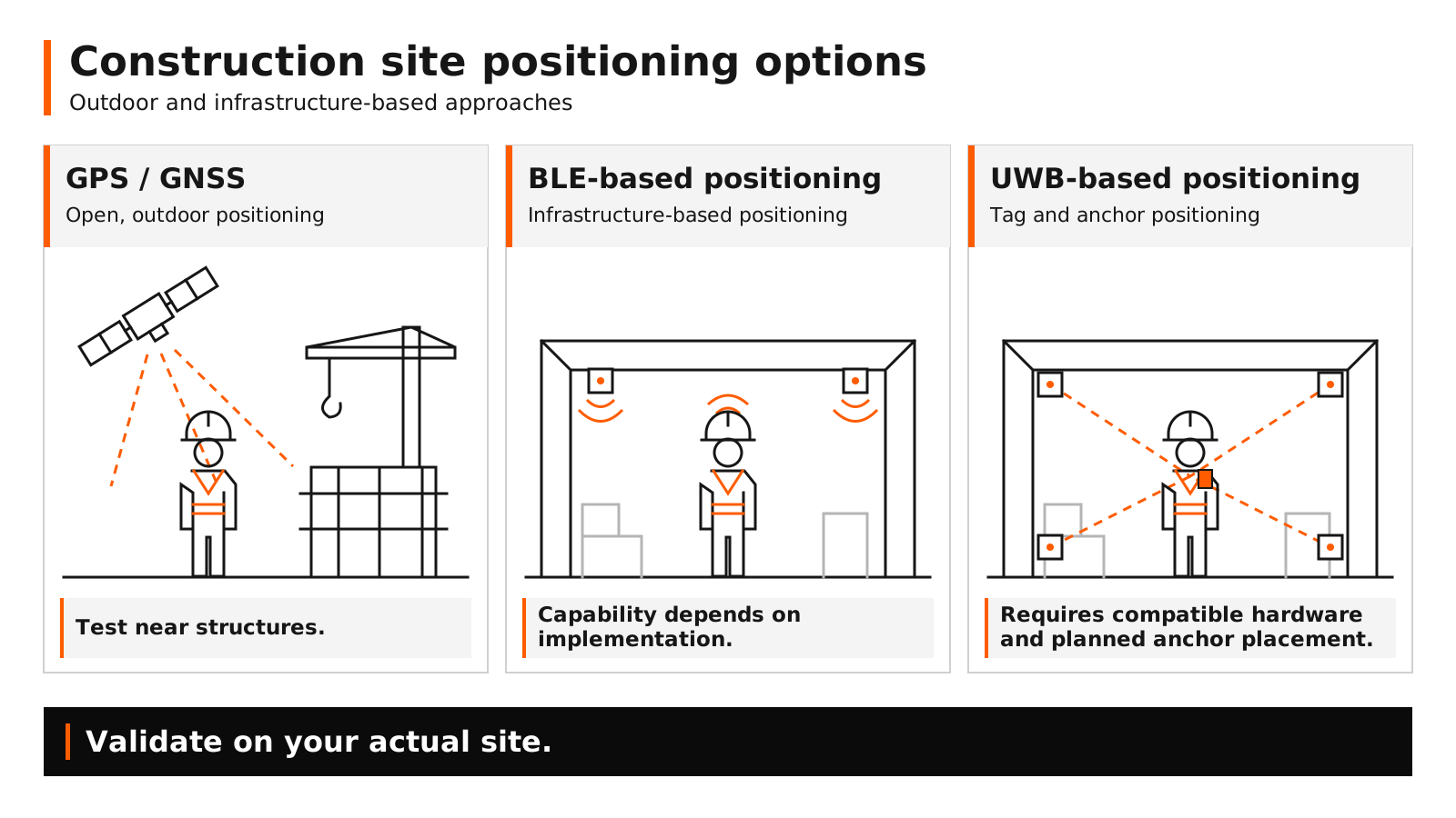
Construction worker location tracking can use different positioning technologies. The right approach depends on the environment and the level of detail required.

GPS is part of the broader family of global navigation satellite systems, or GNSS. GPS.gov’s guidance on positioning accuracy explains that performance depends on factors including signal blockage, satellite geometry, and receiver quality. Buildings can obstruct or reflect signals, affecting the position reported by a device.

Bluetooth Low Energy, or BLE, can support proximity and indoor positioning systems. The Bluetooth SIG’s explanation of direction finding shows why basic proximity detection and more advanced implementations offer different capabilities. The presence of Bluetooth alone does not establish positioning accuracy.

Ultra-wideband, or UWB, can support local positioning using compatible devices and fixed reference points known as anchors.

These are technology options across the market, not a statement that every smart hard hat supports all three.

Ask the supplier to identify exactly what is included in the proposed configuration. If indoor positioning requires additional hardware, that requirement should be clear before procurement.

construction site positioning gps ble uwb

What should you check before choosing a system?

A useful demonstration should reveal how the system behaves during ordinary site conditions and when something goes wrong.

Coverage and location freshness

Walk representative routes, including places where crews actually work. Do not limit testing to the site office or an unobstructed outdoor area.

Ask to see the timestamp of the last location reading and how the interface distinguishes a current update from an older one. Agree on how quickly information needs to refresh for your use case.

A supervisor coordinating crews may tolerate a different reporting interval from a team responding to an urgent request. “Real time” should therefore become a measurable requirement, not remain a sales description.

Geofencing and boundary behaviour

Construction site geofencing uses virtual boundaries to identify events such as a device entering or leaving a defined area.

Before purchasing, establish:

Who creates and updates the zones.

Whether events notify the worker, supervisor, or both.

How delayed updates and uncertain positions are handled.

What happens when a worker remains close to a boundary.

Test ordinary crossings and movement along the edge of a zone. Ask the supplier to show how repeated or incorrect alerts are managed.

Geofencing provides information or warnings. It does not physically prevent access and should not replace barriers, permits, or established site controls.

Connectivity loss

Ask what supervisors see when a device loses its connection. Does the marker remain on the map? Is it clearly labelled as an older position? Is the device shown as offline?

Also confirm whether location records are stored locally and uploaded after reconnection. Historical data recovered later is different from information available during the outage.

Where live updates are unavailable, the operating procedure needs an agreed alternative for contacting and locating workers.

Supervisor action

A location display becomes useful when someone can act on it.

Consider a worker requesting help during an inspection. The supervisor needs to establish whose device sent the request, when its location was updated, and how to contact the worker or responsible crew.

Ask the supplier to demonstrate that sequence using the proposed configuration. Keep responsibility for acknowledgement and escalation explicit within your site procedure.

Access and worker communication

Decide who needs live locations, who can view historical records, and how long those records should remain available. Confirm the applicable privacy and employment requirements with your internal team.

Explain the tracking purpose to workers, including when it operates and who can access the information. Include a straightforward process for correcting device assignments.

These decisions belong in the operating model from the beginning.

What should a supplier demonstrate on your site?

Turn product claims into observable tests. Agree on acceptance criteria before the demonstration so both parties understand what a satisfactory result looks like.

TestWhat to ask the supplier to doWhat your team should inspect

Representative route

Move through outdoor, covered, and enclosed working areas

Where updates remain usable and where coverage changes

Location freshness

Compare device movement with dashboard updates

Delay, timestamps, and identification of stale information

Zone crossing

Enter, leave, and walk along a configured boundary

Correct events, recipients, and unwanted repeated alerts

Connection loss

Safely demonstrate a planned loss of connectivity

Offline indication, last-known location, and recovery behaviour

Device reassignment

Transfer a device between test users

Correct identity in subsequent updates and historical records

Shift workload

Run the expected mix of tracking and communication

Battery performance and charging or replacement needs

Permissions

Sign in using different test roles

Whether each role sees only the information it needs

The acceptance criteria should reflect the buying requirement. If you only need to distinguish broad outdoor work zones, evaluate that outcome. If you need room or floor identification, require a demonstration of that capability.

Document gaps as well as successful tests. This gives procurement, operations, and the supplier a shared record of what the configuration can deliver.

Once suitability is established, use a structured Smart Hard Hat pilot program to assess adoption and ongoing operation with a defined crew.

If your requirements involve existing systems or unusual workflows, review the decision between custom and off-the-shelf Smart Hard Hat platforms before committing to an integration approach.

Is Efour’s Smart Hard Hat suitable for your project?

Start with the site requirement when evaluating Efour’s Smart Hard Hat.

Share the working environments you need to cover, your crew size, shift arrangements, available connectivity, and the location information supervisors need. Use those details to establish which capabilities are supported by the proposed configuration and what must be demonstrated on site.

Keep the evaluation focused on a practical outcome: supervisors should understand whose location they are viewing, how current it is, and what action they can take.

Discuss worker tracking for your site

Share your site environment, crew size, and tracking requirements with Efour to assess Smart Hard Hat suitability.
Discuss your site requirements

Discuss your site requirements

Frequently Asked Questions.

GPS alone should not be assumed to provide reliable indoor or basement positioning. Obstructions affect signal availability and accuracy. If those areas are part of your requirement, ask for a demonstrated positioning approach suited to them.

It depends on the configuration. A device may determine or store its location without a mobile connection, but transmitting live updates requires an available communication path. Ask separately about positioning, live transmission, and later recovery of stored records.

It needs to distinguish the locations relevant to your decisions. Broad zone coordination and locating a person within a particular room or floor require different levels of detail. Define the requirement first, then test it under representative site conditions.

Only use it for those purposes after verifying the relevant workflow. Device assignment errors, unworn devices, missed updates, and incomplete coverage can affect the information available. A location map alone does not establish a dependable attendance or emergency-accounting process.

Related Articles

Precision vision retrofit on the packaging line
Product Engineering

Machine Vision Inspection for Packaging Lines: A Retrofit Buyer’s Guide

Before adding machine vision inspection to an existing packaging line, assess what the retrofit will require. This guide helps packaging-equipment manufacturers evaluate feasibility, specify defect detection and reject handling, and compare supplier quotations against measurable acceptance criteria.

Hitesh Gambhava

Hitesh Gambhava

Nov 17, 2026

Collaborative AI Engineering Lab
Product Engineering

How We Approach AI Product Engineering at Efour

AI product engineering isn’t about adding a model to an existing device. It’s about engineering a physical product in which intelligence, hardware, firmware, connectivity, and manufacturing constraints work together.

Paresh Sagar

Paresh Sagar

Nov 6, 2026

Industrial hard hat visual for the custom versus off-the-shelf platform comparison
Product Engineering

Custom Smart Hard Hat Platform vs Off-the-Shelf: How Industrial Teams Should Decide

For most industrial teams, the right call is neither extreme: start from a proven base helmet, and customize the platform layer that owns your integrations, data and workflows.

Mahil Jasani

Mahil Jasani

Nov 2, 2026

Engineering Solutions to Waste Management
Product Engineering

Engineering Solutions to Waste Management

Waste management has moved past hauling and landfill logistics into a design, materials, and systems problem. This guide breaks down the five categories of engineering solutions to waste management — prevention, circular recycling, energy recovery, treatment and disposal, and smart monitoring — covering what’s proven, what’s emerging, and how different industries apply each one.

Paresh Sagar

Paresh Sagar

Oct 26, 2026